Program Overview
The Total Maximum Daily Load (TMDL) Program identifies sources of pollution to streams, rivers, and lakes within Montana and determines how much pollution those waters can sustain and still fully support beneficial uses. Plans are then written that outline how to reduce pollution to those waters while offering ways to assist local communities with finding solutions to restore and maintain clean water.
TMDL Contacts
Section Supervisor
Christina Staten (406) 444-2836
Water Quality Scientist
Hannah Adkins (406) 444-6871
Water Quality Scientist
Troy Clift (406) 444-2409
Water Quality Scientist
Joseph Vanderwall (406) 444-4071
Water Quality Scientist
Kyle Milke (406) 444-6491
The TMDL development process is a problem solving approach that results in a framework for water quality improvement. DEQ is responsible for completing Total Maximum Daily Load studies. In Montana, the geographic scale for this process includes the complete watershed area of contribution for a pollutant. A TMDL is developed for a single pollutant, such as a metal or sediment. A river, lake, or stream may have multiple pollutants, each with its own TMDL study.
The State of Montana develops reports that may contain multiple TMDLs at a watershed scale. During the TMDL process, waters may be found to be healthier than originally thought, or healthy because of recovery from past polluting practices. These waters are taken off the impaired waters (303(d) list) and do not have a TMDL completed for that pollutant.
Steps in the TMDL Development Process
Each TMDL study is somewhat different because impairments to natural systems of rivers, lakes, and streams vary. However, the process of diagnosis, setting amounts of pollutant reduction, and recommended strategies for repair is very similar.
What is the extent of the problem?
In order to fully evaluate the extent of the problem for each pollutant, a set of parameters to characterize water quality is first identified. Then more detailed information is gathered, focusing on these factors. In addition, numeric targets are developed for many of these parameters. These represent compliance with the applicable Water Quality Standard. The gathered information is compared to the targets to assess the severity of the problem.
Which human activities are contributing to the problem? How much is being contributed?
Human activities that contribute to pollutant loads are identified. The magnitude of contributions from source categories such as crop irrigation, septic systems, and wastewater treatment plants is quantified. As part of this effort, natural background pollutant loading is also quantified.
What is the acceptable total load of pollutants?
The maximum acceptable daily load is identified. Amounts of total pollutant loading above the total maximum daily load (TMDL) need to be reduced in order to solve the problem.
How can this problem be solved?
The amount of reduction needed from each source category is determined to satisfy the TMDL. These are called the allocations. Determining allocations includes social and economic considerations and an assessment of overall feasibility. The goal is to develop a fair and reasonable suite of achievable allocations.
The TMDL Report
The results of these steps are incorporated into a final TMDL report. This provides a planning framework for additional local water quality protection and restoration projects.
What to Expect from a Completed TMDL
A completed TMDL provides information on water quality problems and strategies to reduce pollutants by changing land and water management activities. Implementation to meet a TMDL is voluntary for most activities. A TMDL does not create new regulations, but may affect how existing regulations are implemented.
DEQ Role in TMDL Implementation
Montana DEQ does not implement TMDL pollutant reduction projects for most activities, but can provide technical and financial assistance for stakeholders interested in improving water quality in their areas. DEQ staff:
- Work with participants to use the TMDLs as a basis for developing locally-driven, comprehensive Watershed Restoration Plans.
- Administer funding specifically earmarked to help fund water quality improvement and pollution prevention projects, and can help identify other sources of funds.
Read Understanding the Montana TMDL Process to learn more.
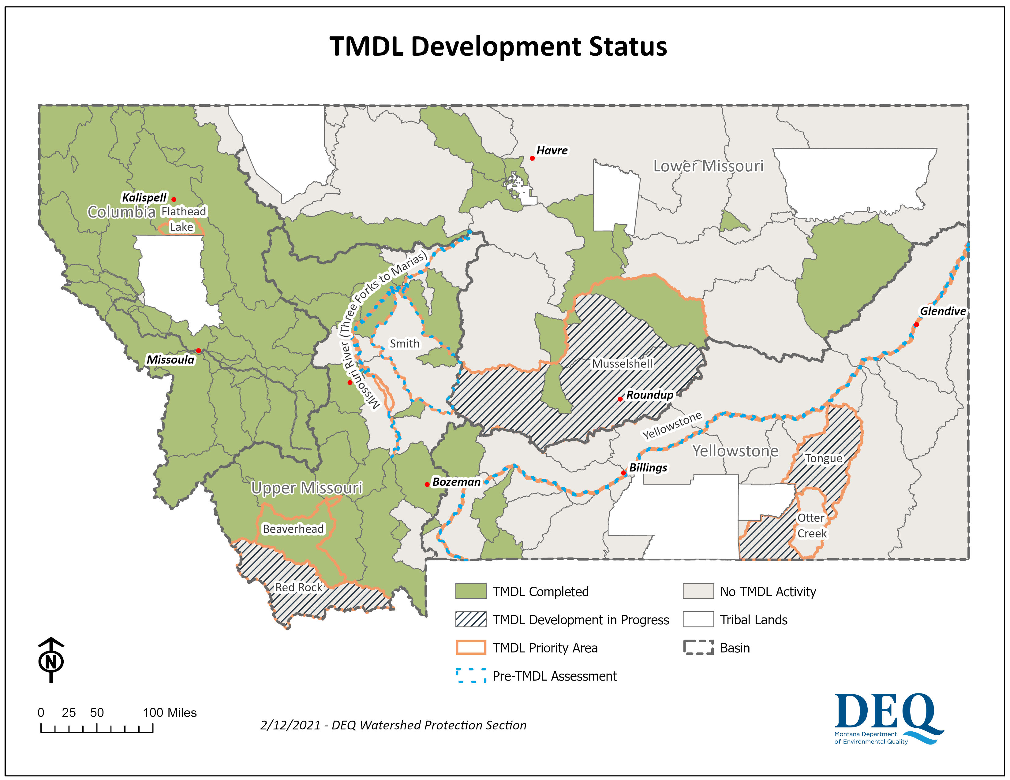
Within Montana, Total Maximum Daily Load (TMDL) studies have been developed in more than 50 different project areas, some representing successful completion of a 2011 amended judgment to a TMDL lawsuit originally filed in 1999. Yet there are many remaining areas that contain impaired waterbody - pollutant combinations that still require TMDL development, all of which are identified on the state's 303(d) list. To address the remaining development requirements, DEQ identifies TMDL development priority areas, discussed below. In watersheds with completed TMDLs, DEQ's nonpoint source program personnel provide support to help implement the TMDLs.
In prioritizing watersheds for TMDL development, DEQ, in consultation with the statewide TMDL advisory group, applies a process that identifies priority factors consistent with state law. The factors with most influence include those linked to the likelihood that local stakeholders will pursue TMDL implementation; the ability to improve coordination among water quality programs; and the recreational, economic and aesthetic importance of the waterbodies in a watershed. The resulting priority watersheds are where DEQ focuses resources toward monitoring and assessing water quality, and subsequently developing TMDLs.
The water quality planning process that includes TMDL development may take two to five years, or more, to complete. TMDL projects normally address multiple types of pollutant impairment causes, organized into pollutant groups. The most common pollutant groups in Montana are: sediment, nutrients, metals, temperature, pathogens, and salinity. Each pollutant group can have unique water quality standards, sources, assessment methods, sampling protocols, corrective measures, and impacts to beneficial uses.
Below is a list of the Montana DEQ TMDL priority areas, along with some general project information and priority rationale. The scheduling approach is consistent with EPA's 303(d) vision which requires states to identify their priority areas for TMDL completion by the end of the calendar year 2032. Note that DEQ may adjust TMDL development priorities based on new information and proposed activities throughout Montana.
Priority Areas Scheduled for Completion in 2026
Beaverhead Watershed
Number of TMDLs Planned
- 26
- Nutrients are the focus of TMDL development
Priority Rationale
- High level of local interest in implementation. (There are 38 completed TMDLs in this watershed. Completing the remaining TMDLs will facilitate a more holistic approach for local stakeholder watershed restoration planning.)
- Important economic resource (fishing, ranching, tourism).
Project Website
Flathead-Stillwater (Ashley Creek) Revision
Number of TMDLs to be Revised
- 10
- Nutrients and sediment in the Ashley Creek watershed are the focus of the revision. No other TMDLs in the 2014 Flathead-Stillwater TMDL document will be revised.
Priority Rationale
- TMDLs were completed in the Flathead-Stillwater TMDL Planning Area in 2014, including 7 nutrient TMDLs and 3 sediment TMDLs in the Ashley Creek subwatershed. A LSPC model was used to aid in source assessment purposes which has been revised after additional data collection took place in the Ashley Creek watershed in 2015 and 2016. The revised model provides more accurate source loading contributions and the TMDLs will therefore be updated to reflect this work.
Red Rock
Number of TMDLs Planned
- 30
- Nutrients are the focus of TMDL development
Priority Rationale
- Sediment, metals, and E. coli TMDLs were completed for this watershed in 2021. Completing the remaining nutrient TMDLs will facilitate a more holistic approach for local stakeholder watershed restoration planning.
Project website coming soon
Priority Areas Scheduled for Completion After 2026
Clarks Fork Yellowstone
Number of TMDLs Planned
- The number of TMDLs to be written will be dependent on the outcome of updated beneficial use assessments
- The focus of TMDL development will be metals, nutrients, E.coli, and sediment
Priority Rationale
- High level of local interest in implementation
- Internal coordination between DEQ water quality programs
Project website coming soon
Gallatin River - Yellowstone National Park boundary to Spanish Creek
Number of TMDLs Planned
- The number of TMDLs to be written will be dependent on the outcome of updated beneficial use assessment that has not yet been performed
- Excess algae and nutrient-related impairments will be the focus of TMDL development
Priority Rationale
- High level of local interest due to algae blooms on the Gallatin River
- Important economic resource (recreation, fishing, tourism)
Project website coming soon
Smith River
Number of TMDLs Planned
- To be determined based on updated beneficial use assessment
- Nutrients and metals will be the focus of TMDL development
Priority Rationale
- High level of local interest due to recurrence of algal blooms on the Smith River.
- Important economic resource (recreation, fishing, ranching, tourism).
Project Website
After TMDL documents are reviewed by stakeholders and the public, they are submitted to the U.S. Environmental Protection Agency (EPA) for approval. Final, EPA approved documents are provided below.
Most of the TMDL documents contain a framework water quality improvement plan that can be used to guide development of local watershed restoration plans. Some documents also address non-pollutant causes of impairment with water quality restoration recommendations that include the same restoration activities needed to satisfy one or more TMDLs contained in the document.
Browse by Watershed
*TMDLs are specific to a waterbody segment - pollutant combination. Some project areas with completed TMDLs may still require TMDL development for additional waterbody-pollutant combinations. Priority areas are subject to change.
Final TMDL Documents
Choose a river basin below to view a list of associated TMDL documents.
Click "Browse Alphabetically" below to view final TMDL documents listed alphabetically in smaller file sizes with appendices and attachments as separate files
Columbia
Bitterroot Watershed
- Bitterroot Watershed Total Maximum Daily Loads and Water Quality Improvement Plan, December 2014
- Bitterroot Temperature and Tributary Sediment Total Maximum Daily Loads and Framework Water Quality Improvement Plan, August 2011
- Water Quality Restoration Plan and TMDLs for the Bitterroot Headwaters TMDL Planning Area, October 2005
- Water Quality Restoration Plan and Total Maximum Daily Loads for the Upper Lolo Creek TMDL Planning Area, April 2003
- Bitterroot River Nutrient Protection Plan, March 2023
- Upper Lolo Sediment TMDL Implementation Evaluation, May 2011
- Reimel Creek TMDL Implementation Evaluation, February 2016
- Bitterroot Headwaters TMDL Implementation Evaluation, January 2021
Blackfoot River Watershed
- Lower Blackfoot Nutrients TMDLs and Water Quality Improvement Plan, September 2013
- Lower Blackfoot Total Maximum Daily Loads and Water Quality Improvement Plan, December 2009
- Middle Blackfoot – Nevada Creek TMDLs and Water Quality Improvement Plan, September 2008
- Middle Blackfoot – Nevada TMDL and Water Quality Improvement Plan Addendum, October 2014
- Blackfoot Headwaters Water Quality and Habitat Restoration Plan and TMDL for Sediment, April 2004
- Blackfoot Headwaters Planning Area Water Quality and Habitat Restoration Plan and TMDL Addendum for Sediment - Sandbar Creek, November 2014
- Water Quality Restoration Plan for Metals in the Blackfoot Headwaters TMDL Planning Area, June 2003
Bobtail Creek
Clark Fork River
Upper Clark Fork
- Silver Bow Creek and Clark Fork River Metals TMDLs, May 2014
- Upper Clark Fork Phase 2 Sediment and Nutrients TMDLs and Framework Water Quality Improvement Plan, April 2014
- Upper Clark Fork River Tributaries Sediment, Metals, and Temperature TMDLs and Framework for Water Quality Restoration, March 2010
- Addendum to Upper Clark Fork River Tributaries Sediment, Metals, and Temperature TMDLs and Framework for Water Quality Restoration, April 2014
- Clark Fork River Voluntary Nutrient Reduction Program, August 1998 (Tri-State Implementation Council)
Central Clark Fork
- Bonita-Superior Project
- Central Clark Fork Basin Tributaries Nutrients, Sediment, & Temperature TMDLs
- Central Clark Fork Basin Tributaries TMDLs and Water Quality Improvement Plan, September 2014
- Bonita Superior Metals TMDLs, May 2013
- Cramer Creek TMDL Implementation Evaluation, March 2019
Lower Clark Fork
Flathead River Basin
- Flathead-Stillwater Planning Area Nutrient, Sediment, and Temperature TMDLs and Water Quality Improvement Plan, December 2014
- Water Quality Protection Plan and TMDLs for the Swan Lake Watershed, June 2004
- Water Quality Assessment and TMDLs for the Flathead River Headwaters Planning Area, December 2004
- Nutrient Management Plan & TMDL for Flathead Lake, December 2001
- Big Creek Watershed Restoration Plan, March 2003
- Big Creek Sediment TMDL Implementation Evaluation, March 2011
- Swan Lake TMDL Implementation Evaluation, July 2017
Flint Creek Watershed
- Flint Nutrients TMDLs and Water Quality Improvement Plan, December 2013
- Flint Creek Planning Area Sediment and Metals TMDLs and Framework Water Quality Improvement Plan, October 2012
- Addendum to Flint Creek Planning Area Sediment and Metals TMDLs and Framework Water Quality Improvement Plan, May 2015
Kootenai-Fisher
Little Blackfoot
Ninemile Creek
Prospect Creek
Rock Creek
St Regis
Swan Lake
- Swan Lake TMDL Implementation Evaluation, July 2017
Thompson River Watershed
Tobacco River Watershed
- Grave Creek Watershed Water Quality and Habitat Restoration Plan and Sediment Total Maximum Daily Loads, March 2005
- Tobacco Planning Area Sediment TMDLs and Framework Water Quality Improvement Plan, September 2011
- Tobacco Planning Area Nutrient and Temperature TMDLs and Water Quality Improvement Plan, September 2014
Yaak
- Yaak River Watershed Sediment Total Maximum Daily Loads, September 2008
- East Fork Yaak River Nutrient Total Maximum Daily Loads, July, 2014
Upper Missouri
Beaverhead River Watershed
- Beaverhead Watershed TMDLs
- Lower Beaverhead - Upper Jefferson Rivers Temperature TMDLs Watershed TMDLs
- Beaverhead Metals TMDLs, September 2020
- Lower Beaverhead and Upper Jefferson Temperature TMDLs, November 2014
- Beaverhead Sediment Total Maximum Daily Loads and Framework Water Quality Protection Plan, July 2012
Big Hole River Watershed
Boulder-Elkhorn Project Area
Dearborn River
Deep Creek
- Development of a TMDL to Reduce Nonpoint Source Sediment Pollution in Deep Creek, Montana, March 1996
- Deep Creek TMDL Implementation Evaluation, November 2011
Gallatin River Watershed
Jefferson River Watershed
Lake Helena Watershed
- Lake Helena Planning Area Metals Total Maximum Daily Load (TMDL) Addendum, September 2013
- Water Quality Restoration Plan TMDLs for the Lake Helena Planning Area, Volume II, August 2006
- Water Quality Restoration Plan TMDLs for the Lake Helena Planning Area Volume 1, December 2004
- Lake Helena Nutrients TMDL Implementation Evaluation, August 2018
Madison River Watershed
- Madison Watershed Stream Summaries 2020 (7.42 MB)
Missouri-Cascade-Belt
Red Rock
Stream Summaries
Ruby
Sheep Creek
- Sheep Creek E. coli TMDL and Water Quality Improvement Plan, September 2017
- Sheep Creek Aluminum TMDL, December, 2020
Sun
Lower Missouri
Big Sandy - Sage
- Big Sandy Creek Salinity TMDL and Water Quality Restoration Plan, January 2002
- Salinity TMDL for Sage Creek, Montana, January 2002
Big Springs
Careless Creek
- Water Quality Restoration Plan for Careless Creek, February 2001
Judith Mountains
- Big Spring Creek Watershed TMDL Implementation Evaluation, December, 2019
Landusky
Lone Tree Creek
- Lone Tree Creek TMDL Addressing Riparian Habitat Degradation, Flow Alteration & Nutrient Enrichment, February 2001
- Lone Tree Creek TMDL Implementation Evaluation, February 2016
Musselshell
Redwater
Teton
Yellowstone
Big Creek
- Big Creek Flow Restoration Plan (TMDL), December 2000
Boulder - Big Timber
- Boulder River Watershed Total Maximum Daily Loads, September 2009
Cooke City
- Cooke City TMDL Implementation Evaluation, July 2011
Otter Creek
Shields
Tongue
Browse Alphabetically
A B C D E F G H I J K L M N O P Q R S T U V W X Y Z
Beaverhead Sediment Total Maximum Daily Loads and Framework Water Quality Protection Plan (3.6 MB)
- Appendix A: Maps and Tables (2.3 MB)
- Appendix B: Regulatory Framework and Reference Condition Approach (0.37 MB)
- Appendix C: 2010/2011 Sediment and Habitat Data Collection Methods and Data Summary – Beaverhead TPA (1.7 MB)
- Appendix D: Additional Sediment Relevant Data Collected in the Beaverhead TPA (0.60 MB)
- Appendix E: Streambank Erosion Source Assessment (0.55 MB)
- Appendix F: Upland Sediment Source Assessment (2.6 MB)
- Appendix G: Unpaved Road Assessment (3.5 MB)
- Appendix H: Total Maximum Daily Loads (0.33 MB)
- Attachment A: Beaverhead River Flushing Flow Study (4.5 MB)
- Attachment B: Memorandum to FWP from Applied Geomorphology in Regards to the Clark Canyon Creek Field Visit, September 13, 2011 (5.5 MB)
- EPA Approval Letter
Beaverhead Metals Total Maximum Daily Loads and Framework Water Quality Protection Plan (3.3 MB)
- Appendix A: Regulatory Framework and Reference Condition Approach (.3 MB)
- Appendix B: Water Quality Data (0.3 MB)
- Appendix C: TMDL Examples and Calculations (.2 MB)
- EPA Approval Letter
Big Creek Watershed Restoration Plan (2.9 MB)
Water Quality Assessment and TMDLs for the Big Spring Planning Area (8.4 MB)
- Appendix A: Big Spring Creek Inventory and Assessment Data, Fergus County Conservation District, June 1990 (16.6 MB)
- Appendix B: Aerial Photography Assessment (Final) Big Spring Creek (0.18 MB)
- Appendix C: Aerial Photography Assessment (Final) Beaver Creek (0.17 MB)
- Appendix D: Aerial Photography Assessment (Final) Cottonwood Creek (0.18 MB)
- Appendix E: Modeling Approach (0.24 MB)
- Appendix F: Response to Public Comments (0.02 MB)
- EPA Approval Letter
Water Quality Restoration Plan and TMDLs for the Bitterroot Headwaters Planning Area (1.3 MB)
- Appendix A: Watershed Characterization Summary and Maps (5.8 MB)
- Appendix B: Mineral Operations (0.07 MB)
- Appendix C: Major Land Resource Areas (0.02 MB)
- Appendix D: GAP Vegetation (0.04 MB)
- Appendix E: Road Assessment Method (0.03 MB)
- Appendix F: BEHI Method (0.01 MB)
- Appendix G: Road Results and Maps (4.6 MB)
- Appendix H: Bank Condition Results and Maps (6.5 MB)
- Appendix I: Fish Population Data (0.02 MB)
- Appendix J: Shade Model Results (0.07 MB)
- Appendix K: Responses to Public Comments (0.08 MB)
- EPA Approval Letter
- Appendix A: Maps and Figures (2.7 MB)
- Appendix B: Bitterroot River Watershed Description (0.47 MB)
- Appendix C: Regulatory Framework and Reference Condition Approach (0.39 MB)
- Appendix D: 2007 Sediment and Habitat Data Collection Methods and Data Summary (0.76 MB)
- Appendix E: 2007 Stream Bank Erosion Source Assessment (1.0 MB)
- Appendix F: Regional Reference and DEQ Summary Statistics Considered for Sediment Target Development (0.38 MB)
- Appendix G: Unpaved Road Sediment Assessment (3.2 MB)
- Appendix H: Sediment Load Estimates and BMP Scenario Reductions (0.51 MB)
- Appendix I: Total Maximum Daily Loads (0.29)
- Attachment A: Bitterroot River FLIR Temperature Analysis Interpretive Report (1.6 MB)
- Attachment B: Modeling Streamflow and Water Temperature in the Bitterroot River, Montana (2.5 MB)
- Attachment C: Modeling Streamflow and Water Temperature in the Bitterroot River, Montana – Addendum A (.30 MB)
- Attachment D: Bitterroot River TMDL Planning Area Missoula MS4 Temperature and Thermal Loading Assessment (0.66 MB)
- EPA Approval Letter
Bitterroot Watershed Total Maximum Daily Loads and Water Quality Improvement Plan (4.4 MB)
- Appendix A: Tables and Figures (4.0 MB)
- Appendix B: Regulatory Framework and Reference Condition Approach (0.29 MB)
- Appendix C: Metals Data (0.47 MB)
- Appendix D: Cleanup/Restoration and Funding Options for Mine Operations or other Sources of Metals Contamination (0.12 MB)
- Attachment A: Modeling Water Temperature in Mill Creek (3.3 MB)
- EPA Approval Letter
Bonita-Superior Metals TMDLs (1.9 MB)
- Appendix A: Maps (7.3 MB)
- Appendix B: Metals Data (0.18 MB)
- Appendix C: Cleanup/Restoration and Funding Options for Mine Operations or Other Sources of Metals Contamination (0.11 MB)
- EPA Approval Letter
Boulder-Elkhorn Metals TMDLs and Framework Water Quality Improvement Plan (5.0 MB)
- Appendix A: Watershed Description Maps (3.0 MB)
- Appendix B: Table of 2012 Impaired Waterbodies, Impaired Uses, and Impairment Status (0.16 MB)
- Appendix C: Regulatory Framework and Reference Condition Approach (0.21 MB)
- Appendix D: Surface Water and Sediment Chemistry Data (1.0 MB)
- Appendix E: Water Chemistry for Natural Background Sites (0.28 MB)
- Appendix F: Source Assessment and Target Departure Analysis (3.3 MB)
- Appendix G: Response to Public Comment (0.39 MB)
- EPA Approval Letter
- Appendix A: Table of Impaired Waterbodies and Watershed Description Maps (1.8 MB)
- Appendix B: Boulder River Watershed Description (0.26 MB)
- Appendix C: Regulatory Framework and Reference Condition Approach (0.23 MB)
- Appendix D: Reference Conditions and Target Value Rationale For Sediment (0.23 MB)
- Appendix E: Nutrient Water Quality Data (0.16 MB)
- Appendix F: Daily Loads (0.18 MB)
- Attachment 1: Analysis of Base Parameter Data and Erosion Inventory Data for Sediment TMDL Development within the Boulder Elkhorn TPA (5.8 MB)
- Attachment 2: Boulder Elkhorn Watershed Sediment Contribution from Hillslope Erosion (1.8 MB)
- Attachment 3: Stream Temperature Assessment for the Boulder River (1.5 MB)
- EPA Approval Letter
Central Clark Fork Basin Tributaries TMDLs and Water Quality Improvement Plan (9.4 MB)
- Appendix A: Status of waterbody impairments in the Central Clark Fork Basin Tributaries TMDL Project Area based on the 2014 Integrated Report (0.16 MB)
- Appendix B: Regulatory Framework and Reference Condition Approach (0.27 MB)
- Appendix C: Sediment Total Maximum Daily Loads (0.29 MB)
- Appendix D: Nemote Creek QUAL2K Model Report (2.8 MB)
- Appendix E: Petty Creek QUAL2K Model Report (3.7 MB)
- Appendix F: Grant Creek QUAL2K Model Report (2.7 MB)
- Attachment A: Sediment and Habitat Assessment (3.7 MB)
- Attachment B: Assessment of Upland Sediment Sources for TMDL Development (2.5 MB)
- Attachment C: Road Sediment Assessment and Modeling (1.8 MB)
- EPA Approval Letter
Water Quality Assessment and TMDLs for the Dearborn River Planning Area (9.1 MB)
- Appendix A (0.05 MB)
- Appendix B (8.5 MB)
- Appendix C (0.17 MB)
- Appendix D (2.9 MB)
- Appendix E (0.15 MB)
- EPA Approval Letter
Elk Creek Restoration Project Survey (0.27 MB)
- Green Mountain Watershed Project Implementation Plan (2.1 MB)
- Elk Creek TMDL Maps (3.6 MB)
- EPA Approval Letter (1.1 MB)
Nutrient Management Plan & TMDL for Flathead Lake, Montana DEQ (5.5 MB)
- Appendix A: Additional Figures (7.0 MB)
- Appendix B: Historical Perspective on Managed Forest Lands (0.14 MB)
- Appendix C: Current Flathead Lake Monitoring Program (0.33 MB)
- Appendix D: Responses to Public Comment (0.21 MB)
- EPA Approval Letter
Water Quality Assessment and TMDLs for the Flathead River Headwaters Planning Area, Montana (6.8 MB)
- Appendix C: 2002 and 2003 Field Sampling Data (25.2 MB)
- EPA Approval Letter
- Appendix A: Regulatory Framework and Reference Condition Approach (0.28 MB)
- Appendix B: Chemistry, Flow, Fish Distribution, and Permitted Point Sources Data (0.38 MB)
- Appendix C: Sheppard/Logan Road BMPs Since 2004 (2.9 MB)
- Appendix D: Sediment Total Maximum Daily Loads (0.20 MB)
- Appendix E: QUAL2K Stream Temperature Modeling for Ashley Creek and the Whitefish River (1.8 MB)
- Appendix F: Response to Public Comments (0.23 MB)
- Attachment A: Flathead Stillwater TMDL Planning Area Sediment and Habitat Assessment Summary Report (4.5 MB)
- Attachment B: Summary of Permitted Point Sources in the Flathead Lake Basin (5.4 MB)
- Attachment C: Summary of Urban Stormwater Sources in the Flathead Lake Basin (1.8 MB)
- EPA Approval Letter
Flint Creek Planning Area Sediment and Metals TMDLs and Framework Water Quality Improvement Plan (2.5 MB)
- Appendix A: Maps (10.5 MB)
- Appendix B: Data (0.66 MB)
- Appendix C: Regulatory Framework and Reference Condition (0.40 MB)
- Appendix D: Reference Conditions and Target Value Rationale (0.18 MB)
- Appendix E: Unpaved Road Assessment: Sediment Load Estimations and Potential Reductions (0.26 MB)
- Appendix F: Daily Loads (0.14 MB)
- Attachment A: Analysis of Base Parameter Data and Erosion Inventory Data for Sediment TMDL Development Within The Flint Creek TPA (4.4 MB)
- Attachment B: Flint Creek Watershed Sediment Assessment: Upland Sediment Assessment and Modeling and BMP Effectiveness and Percent Reduction Potential (1.3 MB)
- EPA Approval Letter
- Appendix A: Location of Mining-Related Features and Water Quality Sample Sites (0.53 MB)
- Appendix B: Cleanup/Restoration and Funding Options for Mine Operations or Other Sources of Metals Contamination (0.13 MB)
- Attachment A: Analytical Results Report for a CERCLA Site Inspection Philipsburg Mining Area (Douglas Creek) Near Philipsburg, Granite County, Montana (4.8 MB)
- EPA Approval Letter
Flint Nutrients TMDLs and Water Quality Improvement Plan (3.4 MB)
- Appendix A: Table of Impaired Waterbodies, Their Impaired Uses, and Impairment Status on the 2012 Water Quality Integrated Report (0.14 MB)
- Appendix B: Watershed Description Figures (8.5 MB)
- Appendix C: Fish Species, Surface Water Nutrients, Chlorophyll-a, Macroinvertebrates and Philipsburg Wastewater Treatment Plant Data (0.36 MB)
- Appendix D: Regulatory Framework and Reference Condition Approach (0.19 MB)
- Appendix E: Flint Creek Watershed Nutrient Assessment (17.5 MB)
- Appendix F: Subsurface Wastewater Treatment Systems in the Flint Creek Watershed (0.34 MB)
- Appendix G: Flint Creek TMDL Planning Area Nutrient Source Review, Task 1: Discrete Source Characterization, Granite and Deerlodge Counties (1.6 MB)
- EPA Approval Letter
- Appendix A: Harvest Analysis Summary (0.23 MB)
- Appendix B: Roads Analysis Summary (0.44 MB)
- Appendix C: Rain-On-Snow, Water Yield, Equivalent Clearcut Acreage and Peak Flow Increases Analysis Summary (0.08 MB)
- Appendix D: Fisheries and Aquatic Life (0.06 MB)
- Appendix E: Regulatory Framework and TMDL Development (0.10 MB)
- Appendix F: Summary of Data Collection and Assessment Methodologies (0.05 MB)
- Appendix G: Stream Conditions (0.36 MB)
- Appendix H: Reference Value Development for the Grave Creek Watershed (0.17 MB)
- Appendix I: Road Surface Sediment Analysis Methods and Results (0.08 MB)
- Appendix J: In-stream Sediment Source Analysis (0.20 MB)
- Appendix K: Response to Comments (0.16 MB)
- EPA Approval Letter
Judith Mountains Project Area TMDLs and Framework Water Quality Improvement Plan (3.3 MB)
- Appendix A: Figures and Tables (5.1 MB)
- Appendix B: Regulatory Framework and Reference Condition Approach (0.29 MB)
- Appendix C: Chippewa Creek Sediment Assessment (2.8 MB)
- Appendix D: Judith Mountains Project Area Metals Source Assessment (0.18 MB)
- Appendix E: Sediment Total Maximum Daily Loads (0.14 MB)
- EPA Approval Letter
- Appendix A: Table of Waterbody Impairments and Project Area Description Maps (4.8 MB)
- Appendix B: Regulatory Framework and Reference Condition Approach (0.34 MB)
- Appendix C: Upland Erosion Sediment Assessment (3.5 MB)
- Appendix D: Road Sediment Assessment (4.4 MB)
- Appendix E: Total Maximum Daily Loads (0.23 MB)
- Appendix F: Nutrient and Metals Water Quality Data for Impaired Streams in the Kootenai-Fisher TMDL Planning Area (0.55 MB)
- Appendix G: Wolf Creek QUAL2K Model Report (7.5 MB)
- Appendix H: Cleanup/Restoration and Funding Options for Mine Operations or Other Sources of Metals Contamination (0.12 MB)
- Appendix I: Response to Public Comments (0.55 MB)
- Attachment A: Kootenai-Fisher TMDL Project Area Sediment and Habitat Assessment (4.9 MB)
- EPA Approval Letter
Water Quality Restoration Plan TMDLs for the Lake Helena Planning Area Volume 1 (1.9 MB)
- Appendix A: Watershed Characterization (5.2 MB)
- Appendix B: Montana Water Quality Standards (0.53 MB)
- Appendix C: Preliminary Source Assessment (1.0 MB)
- Appendix D: Nutrient Data for Impairment Status Determination (Available on Request)
- Appendix E: GWLF/Bathtub Modeling for Lake Helena (0.41 MB)
- Appendix F: Sediment Data for Impairment Status Determination (Available on Request)
- Appendix G: Metals Data for Impairment Status Determination (Available on Request)
- Appendix H: SSTEMP Model (0.31 MB)
- Appendix I: Silver Creek Mercury Fish Tissue Data (see the 2013 Lake Helena metals TMDL document for updated data)
- Appendix J: Multi-Resolution Land Characteristics (MRLC) Consortium Data Description
- Appendix K: Supplemental Data (Available on Request)
Water Quality Restoration Plan TMDLs for the Lake Helena Planning Area Volume II (2.4 MB)
- Appendix A: Total Maximum Daily Load (TMDL) Summary (2.0 MB)
- Appendix B: DEQ and EPA Responses to Public Comments (0.22 MB)
- Appendix C: GWLF/BATHTUB Modeling Results (2.0 MB)
- Appendix D: Supplemental Sediment Source Assessment Results (1.1 MB)
- Appendix E: Permitted Point Source Discharges (1.1 MB)
- Appendix F: LSPC Metals Modeling Results (4.1 MB)
- Appendix G: SSTEMP Temperature Modeling Results (0.47 MB)
- Appendix H: Supplemental Monitoring and Assessment Strategy (0.12 MB)
- Appendix I: Phased Wasteload Allocation Strategy (0.08 MB)
- Appendix J: Wasteload Allocations for Regulated Stormwater Discharges (0.23 MB)
- Appendix K: On-Site Domestic Wastewater Treatment Requirements and Alternatives (0.12 MB)
- EPA Approval Letter
Landusky Metals Total Maximum Daily Loads and Framework Water Quality Improvement Plan (3.5 MB)
- Appendix A: TMDL Status Summary Table and Maps (3.0 MB)
- Appendix B: Surface Water Chemistry Data (3.4 MB)
- Appendix C: Surface Water Chemistry Data - Selected Background Sites (0.51 MB)
- Appendix D: Groundwater Chemistry Examples Zortman and Landusky Mines (0.38 MB)
- Appendix E: Landusky TMDL Planning Area Fish Distribution Report (0.25 MB)
- Appendix F: Target Departure Analysis (2.2 MB)
- EPA Approval Letter
Little Blackfoot River Watershed TMDLs and Framework Water Quality Improvement Plan (3.8 MB)
- Appendix A: Figures and Tables (4.2 MB)
- Appendix B: Regulatory Framework and Reference Condition Approach (0.48 MB)
- Appendix C: 2009 Sediment and Habitat Assessment (2.2 MB)
- Appendix D: Little Blackfoot River Watershed Sediment and Nutrient Assessment (1.9 MB)
- Appendix E: Road Sediment Assessment (2.4 MB)
- Appendix F: Detailed Source Assessment and Data Review (0.44 MB)
- Appendix G: Metals and Nutrient Water Quality Data (0.69 MB)
- Appendix H: Response to Public Comments (0.31)
- EPA Approval Letter
Lone Tree Creek TMDL Addressing Riparian Habitat Degradation, Flow Alteration & Nutrient Enrichment (0.75 MB)
Lower Clark Fork Tributaries Sediment TMDLs and Framework for Water Quality Restoration (2.5 MB)
- Appendix A: Maps (5.3 MB)
- Appendix B: Lower Clark Fork Tributaries TMDL Planning Area Sediment Monitoring Report (5.7 MB)
- Appendix C: Lower Clark Fork Tributaries Stratification Tables (0.32 MB)
- Appendix D: Reference Conditions and Target Value Rationale (0.43 MB)
- Appendix E: Total Maximum Daily Loads (0.28 MB)
- Attachment 1: Road Sediment Assessment & Modeling (4.1 MB)
- Attachment 2: Sediment Contribution from Hillslope Erosion (1.9 MB)
- EPA Approval Letter
Lower Beaverhead River and Upper Jefferson River Temperature TMDLs (3.6 MB)
- Appendix A: Regulatory Framework and Reference Condition Approach (0.18 MB)
- Appendix B: Beaverhead River Temperature Model (1.5 MB)
- Appendix C: Upper Jefferson River Temperature Model (1.3 MB)
- Appendix D: Temperature and Flow Data (0.17 MB)
- Attachment A: Evaluation of Fishery Trends in the Jefferson River Drainage Related to Changes in Streamflow Pattern and Habitat Restoration Activities (2.3 MB)
- EPA Approval Letter
Lower Gallatin Planning Area TMDLs & Framework Water Quality Improvement Plan (7.2 MB)
- Appendix A: Figures and Tables (8.4 MB)
- Appendix B: Regulatory Framework and Reference Condition Approach (0.28 MB)
- Appendix C: Road Sediment Assessment (1.0 MB)
- Appendix D: Sediment Total Maximum Daily Loads (0.19 MB)
- Appendix E: Hyalite Creek Nutrient Listing History and TMDL Development (0.24 MB)
- Appendix F: Nutrient Existing Load Source Assessment in the Lower Gallatin TMDL Planning Area (7.7 MB)
- Appendix G: Method Used to Model Water Reclamation Facility Discharge in the East Gallatin River (0.77 MB)
- Appendix H: Response to Public Comments (0.26 MB)
- Attachment A: Sediment and Habitat Assessment (3.5 MB)
- Attachment B: 2009 Lower Gallatin TMDL Planning Area Nutrient, Algae and E. Coli Source Assessment (34.8 MB)
- Attachment C: Upland Sediment Assessment (1.0 MB)
- Attachment D: City of Bozeman Hydrologic Model Report (3.6 MB)
- EPA Approval Letter
- EPA Approval Letter for pH Errata
Madison Sediment and Temperature TMDLs and Water Quality Improvement Plan – September 2020 (7.21 MB)
- Appendix A: Regulatory Framework and Reference Condition Approach
- Appendix B: Sediment Data Collection Methods and Summaries of Monitored Waterbodies with No TMDL Written
- Appendix C: Bank Erosion Assessment, Madison TMDL Planning Area
- Appendix D: Road Sediment Assessment, Madison TMDL Planning Area
- Appendix E: Upland Sediment Assessment for Elk Creek
- Appendix F: Sediment Total Maximum Daily Load Estimates
- Appendix G: Madison Temperature Study Data Collection
- Appendix H: Temperature Conditions for Lower Madison River and West Fork Madison River
- Appendix I: Shade Targets and Target Development Data for Temperature TMDLs in the Madison TMDL Planning Area
- Appendix J: Qual2k Temperature Analysis, Description, and Constraining Parameters
- EPA Approval Letter
Madison Watershed Stream Summaries 2020 (7.42 MB)
Madison Nutrient, E. coli, and Metal TMDLs and Water Quality Improvement Plan (7.2 MB)
- Appendix A: Surface Water Nutrient, E. coli, and Metal Data for the Madison TMDL Planning Area (.5 MB)
- Appendix B: Method for Estimating Attenuation of Nutrients from Septic Systems Model Results (MEANSS) for the Madison TMDL Planning Area (0.20 MB)
- EPA Approval Letter
Middle Blackfoot-Nevada Creek TMDLs and Water Quality Improvement Plan (6.5 MB)
- Appendix A: Figures and Maps (8.5 MB)
- Appendix B: Aerial Assessment and Reconnaissance Results (0.20 MB)
- Appendix C: Stream Bank Erosion Inventory (0.04 MB)
- Appendix D: Sediment/Habitat Target Development (0.27 MB)
- Appendix E: Example of Daily Sediment TMDLs, Upper Nevada Creek (0.07 MB)
- Appendix F: Water Quality Analysis Results for Field Parameters and Trace Metals (0.41 MB)
- Appendix G: Representative Reference Shade Conditions and Daily Temperature Loading (0.55 MB)
- Appendix H: Restoration Plan (0.08 MB)
- Appendix I: Streamflow, Sediment, and Nutrient Simulation Using SWAT (0.43 MB)
- Appendix J: Sediment Loading Analysis (0.12 MB)
- Appendix K: Response to Public Comments (0.18 MB)
- EPA Approval Letter
Middle Blackfoot-Nevada TMDL and Water Quality Improvement Plan Addendum (3.0 MB)
- Appendix A: Total Maximum Daily Loads (0.14 MB)
- Appendix B: Metals Data (0.38 MB)
- Attachment A: Temperature Analysis and Modeling of 303(d) List Streams in the Blackfoot River Watershed, Montana (3.3 MB)
- EPA Approval Letter
Middle and Lower Big Hole Planning Area TMDLs and Water Quality Improvement Plan (1.8 MB)
- Appendix A: Maps (4.7 MB)
- Appendix B: Regulatory Framework and Reference Condition Approach (0.17 MB)
- Appendix C: Sediment Contribution from Roads (0.29 MB)
- Appendix D: Sediment Contribution from Hillslope Erosion (0.68 MB)
- Appendix E: Sediment Contribution from Streambank Erosion (0.24 MB)
- Appendix F: Daily TMDLs for Sediment and Temperature (0.21 MB)
- Appendix G: Nutrient Model (1.1 MB)
- Appendix H: Sediment/Metals Data (0.32 MB)
- Appendix I: Big Hole River Temperature Model (2.2 MB)
- Appendix J: Divide Creek Temperature Model (0.32 MB)
- Appendix K: Response to Public Comments (0.04 MB)
- EPA Approval Letter
- Appendix A: Maps and Figures (3.0 MB)
- Appendix B: Regulatory Framework and Reference Condition Approach (0.09 MB)
- EPA Approval Letter
Musselshell E. coli TMDLs and Water Quality Improvement Plan, August 2021 (5.03 MB)
Musselshell E. coli TMDLs and Water Quality Improvement Plan, Appendix A
Water Quality Restoration Plan and TMDLs for the Ninemile Planning Area (2.3 MB)
- Appendix A: Ninemile TMDL Fish Passage Assessment and Recommendations for Forest-Managed Lands (0.06 MB)
- Appendix B: Forest Road Sediment Assessment Method (FROSAM), Results and Maps (4.2 MB)
- Appendix C: DEQ Responses to Public Comments (0.11 MB)
- Maps (7.8 MB)
- EPA Approval Letter
- Appendix A: Regulatory Framework and Reference Condition Approach (0.2 MB)
- Appendix B: Water Quality Data (1.11 MB)
- Appendix C: Metal TMDL Examples and Calculations (0.1 MB)
- Appendix D: Sediment Data Collection Methods and Summaries of Monitored Waterbodies with No TMDL Written (1.77 MB)
- Appendix E: Bank Erosion Assessment (1.45 MB)
- Appendix F: Unpaved Road Sediment Assessment (0.2 MB)
- Appendix G: Upland Sediment Assessment (1.45 MB)
- Appendix H: Sediment Total Maximum Daily Load Estimates (0.6 MB)
- EPA Approval Letter
- Red Rock Watershed Stream Summaries 2022 (29.1 MB)
Redwater River Nutrient and Salinity TMDLs and Framework Water Quality Improvement Plan (1.2 MB)
- Appendix A: Maps and Data (1.6 MB)
- Appendix B: Data Tables (1.6 MB)
- Appendix C: Reference Condition Approach (0.04 MB)
- Appendix D: Redwater Nutrient Modeling Report (0.33 MB)
- Appendix E: Nitrate Sensitivity Analysis (0.11 MB)
- Appendix F: Response to Public Comments (0.11 MB)
- EPA Approval Letter
Rock Creek Watershed TMDLs and Water Quality Improvement Plans (8.4 MB)
- Appendix A: Maps (4.9 MB)
- Appendix B: Regulatory Framework and Reference Condition Approach (0.30 MB)
- Appendix C: Analysis of Base Parameter Data and Erosion Inventory Data for Sediment TMDL Development within the Rock TPA (3.4 MB)
- Appendix D: Rock TPA Biological Sampling 2011: Macroinvertebrate and Periphyton Results (1.7 MB)
- Appendix E: Streambank Erosion Source Assessment – Rock Creek TPA (0.34 MB)
- Appendix F: Rock TPA Assessment of Upland Sediment Sources for TMDL Development (2.5 MB)
- Appendix G: Rock Creek TPA Road Sediment Assessment & Modeling (4.4 MB)
- Appendix H: Sediment Total Maximum Daily Loads (0.16 MB)
- Appendix I: East Fork Rock Creek Temperature Modeling Report (5.1 MB)
- Appendix J: South Fork Antelope Creek Temperature Modeling Report (3.9 MB)
- Appendix K: Nutrient Water Quality Data (0.19 MB)
- Appendix L: Surface Water and Sediment Metals Data, Rock Creek TMDL Planning Area (0.25 MB)
- Appendix M: Source Assessment and Target Departure Analysis (4.0 MB)
- Appendix N: Cleanup/Restoration and Funding Options For Mine Operations Or Other Sources Of Metals Contamination (0.12 MB)
- EPA Approval Letter
Ruby River Watershed Total Maximum Daily Loads and Framework for a Water Quality Restoration Plan (6.9 MB)
- Appendix A: Maps (11.2 MB)
- Appendix B: Reference Approach (0.07 MB)
- Appendix C: Temperature Model and Analysis of the Lower Ruby River and Mill Creek (0.21 MB)
- Appendix D: Sediment and Physical Data (0.02 MB)
- Appendix E: Sediment Monitoring and Assessment (0.08 MB)
- Appendix F: Pictures (23.4 MB)
- Appendix G: Forward Looking Infrared Reports (1.9 MB)
- Appendix H: Upland Sediment Models (12.0 MB)
- Appendix I: Response to Public Comments (0.18 MB)
- EPA Approval Letter
Sheep Creek Aluminum TMDL (2.1 MB)
- Appendix A: Maps (2.0 MB)
- Appendix B: Data (0.3 MB)
- EPA Approval Letter (.5 MB)
Shields River Watershed Water Quality Planning Framework and Sediment TMDLs (1.1 MB)
- Appendix A: Maps (5.9 MB)
- Appendix B: Regulatory Framework and Reference Condition Approach (0.07 MB)
- Appendix C: Reference Value Development and Target Justification (0.05 MB)
- Appendix D: Sediment Contribution from Roads (0.68 MB)
- Appendix E: Sediment Contribution from Hillslope Erosion (0.15 MB)
- Appendix F: Sediment Contribution from Streambank Erosion (0.68 MB)
- Appendix G: Daily TMDLs (0.15 MB)
- Appendix H: Restoration Priorities for the Shields Valley Watershed Group (0.05 MB)
- Appendix I: Sediment and Habitat Assessment and Data (0.25 MB)
- Appendix J: Response to Public Comments (0.06 MB)
- EPA Approval Letter
Water Quality Protection Plan and TMDLs for the Swan Lake Watershed (2.6 MB)
- Appendix A: Applicable Water Quality Standards (0.04 MB)
- Appendix B: Impairment Determination Listing Details for the 1996 and 2002 303(d) Lists (0.04 MB)
- Appendix C: Summary Ecological Classification Swan River Basin, Montana (2.5 MB)
- Appendix D: Mapping Chlorophyll Distribution Over Lakes of Northwest Montana (0.27 MB)
- Appendix E: Forest Road Sediment Assessment Methodology (0.10 MB)
- Appendix F: Forest Roads Sediment Results (9.1 MB)
- Appendix G: Swan Bank Inventory Results (0.80 MB)
- Appendix H: Local Stream Corridor Protective Regulations and Covenants (0.50 MB)
- Appendix I: Riparian Assessment & Characterization of the Swan River & Select Tributaries (0.21 MB)
- Appendix J: Tributary Physical Assessment for TMDL Development Support (0.24 MB)
- Appendix K: DEQ Response to Public Comment (0.13 MB)
- EPA Approval Letter
Water Quality Management Plan and TMDLs for the Teton River Watershed (5.3 MB)
- Appendix A: Thematic Maps of the Teton River Watershed (28.0 MB)
- Appendix B: Water Quality Data Maps (1.1 MB)
- Appendix C: Macroinvertebrate Results (0.04 MB)
- Appendix D: Selected Montana Water Laws and Administrative Rules (0.04 MB)
- Appendix E: Public Comments and Responses (0.24 MB)
- Appendix F: Press Releases During Public Comment Period (0.23 MB)
- EPA Approval Letter
- Appendix A: Table of Waterbody Impairments and Project Area Description Maps (3.8 MB)
- Appendix B: Regulatory Framework and Reference Condition APproach (0.32 MB)
- Appendix C: Total Maximum Daily Loads (0.28 MB)
- Appendix D: Nutrient and Metals Water Quality Data (0.34 MB)
- Attachment A: Sediment and Habitat Assessment (2.0 MB)
- Attachment B: Upland Erosion Assessment (1.3 MB)
- Attachment C: Unpaved Roads Assessment (1.6 MB)
- Attachment D: Modeling Water Temperature in Lynch Creek (2.5 MB)
- Attachment E: Modeling Water Temperature in McGregor Creek (5.7 MB)
- EPA Approval Letter
Tobacco Planning Area Nutrient and Temperature TMDLs and Water Quality Improvement Plan (2.8 MB)
- Appendix A: Maps and Tables (2.1 MB)
- Appendix B: QUAL2K Model Report (3.2 MB)
- Appendix C: Nutrient Data (0.12 MB)
- EPA Approval Letter
Tobacco Planning Area Sediment TMDLs and Framework Water Quality Improvement Plan (2.8 MB)
- Appendix A: Maps and Tables (5.5 MB)
- Appendix B: Tobacco River Watershed Description (0.46 MB)
- Appendix C: Regulatory Framework and Reference Condition Approach (0.38 MB)
- Appendix D: Sediment and Habitat Assessment (2.9 MB)
- Appendix E: Streambank Erosion Source Assessment (1.0 MB)
- Appendix F: Tobacco River Watershed Upland Sediment Source Assessment (1.7 MB)
- Appendix G: Road Sediment Assessment, Tobacco TMDL Planning Area (2.2 MB)
- Appendix H: Total Maximum Daily Loads (0.40 MB)
- Appendix I: Response to Public Comments (0.33 MB)
- EPA Approval Letter
Upper Clark Fork Phase 2 Sediment and Nutrients TMDLs and Framework Water Quality Improvement Plan (11.5 MB)
- Appendix A: Figures and Tables (5.6 MB)
- Appendix B: Regulatory Framework and Reference Condition Approach (0.25 MB)
- Appendix C: 2011 Sediment and Habitat Assessment (0.60 MB)
- Appendix D: Sediment Total Maximum Daily Loads (0.20 MB)
- EPA Approval Letter
- Appendix A: Maps (15.8 MB)
- Appendix B: Reference Conditions and Target Value Rationale (0.04 MB)
- Appendix C: Total Maximum Daily Loads (0.13 MB)
- Appendix D: Data (0.31 MB)
- Appendix E: Road Network Aerial Assessment Upper Clark Fork TMDL Planning Area (0.11 MB)
- Appendix F: Upland Sediment Model Scenario Development (0.03 MB)
- Appendix G: Stream Temperature Assessment for Peterson Creek Upper Clark Fork TMDL Planning Area (0.23 MB)
- Appendix H: Stream-Irrigation Network Relationship in the Upper Clark Fork TMDL Planning Area (1.6 MB)
- Appendix I: Sediment Loads and Reduction Determinations (0.08 MB)
- EPA Approval Letter
- Appendix J: Browns Gulch Sediment Assessment (0.39 MB)
- EPA Approval Letter
Upper Jefferson River Tributary Sediment TMDLs and Framework Water Quality Improvement Plan (1.5 MB)
- Appendix A: Watershed Characterization Report Jefferson River Water Quality Restoration Planning Areas (7.6 MB)
- Appendix B: Regulatory Framework and Reference Condition Approach (0.07 MB)
- Appendix C: 2004 Aerial Photo Review and Field Source Assessment, Upper Jefferson River Watershed (11.5 MB)
- Appendix D: Upland USLE Based Sediment Model, Sediment Contribution From Hillslope Erosion For Tributaries of the Upper Jefferson TMDL Planning Area (0.17 MB)
- Appendix E: USLE Generated Upland Erosion Corrected for Existing and Potential Riparian Health (0.13 MB)
- Appendix F: Unpaved Road Sediment Assessment, Upper Jefferson River TMDL Planning Area (1.4 MB)
- Appendix G: Streambank Erosion Source Assessment, Upper Jefferson River Water Quality Restoration Planning Area (0.40 MB)
- Appendix H: Total Maximum Daily Loads (0.16 MB)
- EPA Approval Letter
- Appendix A: Sediment Contribution From Hillslope Erosion (0.40 MB)
- Appendix B: Modeling Stream Temperatures in the Upper Big Hole River – 2003 (0.54 MB)
- Appendix C: Data Summary Appendix (0.38 MB)
- Appendix D: Modeling Streamflow and Water Temperature in The Big Hole River, Montana – 2006 (2.2 MB)
- Appendix E: Temperature Daily TMDLs and Instantaneous Loads (0.12 MB)
- Appendix F: Sediment Total Maximum Daily Loads (0.13 MB)
- Appendix G: Sediment Contribution from Road Erosion (0.11 MB)
- Appendix H: Sediment Contribution from Streambank Erosion (0.27 MB)
- Appendix I: Big Hole River Watershed Nutrient TMDL GWLF Monitoring Documentation (1.1 MB)
- Appendix J: Streamside Vegetation Nutrient Filtering Function (0.03 MB)
- Appendix K: Upper and North Fork Big Hole River Planning Area TMDL Maps (3.5 MB)
- Appendix L: Response to Public Comments (0.07 MB)
- EPA Approval Letter
West Fork Gallatin River Watershed TMDL and Framework Watershed Water Quality Improvement Plan (3.0 MB)
- Appendix A: Maps and Figures (3.3 MB)
- Appendix B: Regulatory Framework and Reference Condition Approach (0.17 MB)
- Appendix C: Sediment Total Maximum Daily Loads (0.05 MB)
- Appendix D: Streambank Erosion Source Assessment (0.38 MB)
- Appendix E: Hillslope Sediment Model and Riparian Health Addendum (0.72 MB)
- Appendix F: Unpaved Road Sediment Assessment (0.79 MB)
- Appendix G: 2008 Sediment and Habitat data collection Methods and Data Summary Upper Gallatin TMDL Planning Area (0.62 MB)
- Appendix H: Response to Public Comments (0.02 MB)
- EPA Approval Letter
White Pine Creek Temperature TMDL (3.6 MB)
- Appendix A: Regulatory Framework and Reference Condition Approach (0.17 MB)
- Appendix B: White Pine Creek QUAL2K Model Report (3.2 MB)
- EPA Approval Letter
Yaak River Watershed Sediment Total Maximum Daily Loads (2.3 MB)
- Appendix A: Field Sediment Source Surveys (0.63 MB)
- Appendix B: Unpaved Road Sediment Assessment (0.65 MB)
- Appendix C: Daily Sediment TMDLs (0.10 MB)
- Appendix D: Maps (0.01 MB)
- Appendix E: Responses to Public Comments (0.09 MB)
- EPA Approval Letter
East Fork Yaak River Nutrient Total Maximum Daily Loads (1.4 MB)
- Appendix A: Maps (4.3 MB)
- Appendix B: Regulatory Framework and Reference Condition Approach (0.24 MB)
- EPA Approval Letter
DEQ is required to assess the waters for which TMDLs have been completed to determine whether compliance with water quality standards has been attained. This assessment will use the suite of objectives specified in the TMDL document to measure compliance with water quality standards and achievement of full support of all applicable beneficial uses.
The outline below describes the evolving framework and components for the DEQ TMDL Implementation Evaluation (TIE). The TIE should document progress made toward meeting: TMDL objectives, water quality standards, and beneficial uses in the impaired water bodies. Although these assessments will likely require different sets of data for evaluation, each may be evaluated as part of the evaluation. It is important to note that elements of the implementation strategy are largely voluntary in nature for nonpoint pollution sources. The purpose of the TIE is to:
- Recognize and document implementation of reasonable land, soil, and water conservation practices;
- Assist in determining the effectiveness of those practices on water quality improvement;
- Assess progress towards meeting water quality standards;
- Provide recommendations for changes in implementation activities, monitoring, or address changes in the watershed that are likely to impact water quality;
- Promote TMDL implementation and beneficial use support.
Protection plans are a nonregulatory approach for protecting high quality waters that can be developed by state or local entities. Protection Plans incorporate voluntary protective actions that can be taken by point sources and municipalities, whereas Watershed Restoration Plans typically focus on nonpoint source pollution issues and landowner-scale actions. Both types of plans are highly valuable for their varied stakeholder engagement and ability to inform ongoing and future planning efforts.
Engaging in water quality protection can help avoid costs associated with:
- lost revenue from recreation, property value, and other beneficial uses;
- expanded restoration efforts; and
- increased water treatment.
Completed Protection Plans
- Bitterroot River Nutrient Protection Plan, March 2023